
Heavy snowfall in southern Germany and along the Alps is a challenging yet rewarding weather condition to forecast and can result in both positive and negative consequences depending on how you look at it. It is challenging because the atmospheric conditions must afford the opportunity. It is rewarding when you do your research, recognize the patterns and nail the forecast as opposed to being caught off guard having not recognized the weather system setup. It can be extremely positive to the avid skier or snowboarder in the southern regions of Germany and the Alps, but very negative to the motorist on the Autobahn dealing with extreme traffic delays. Weather patterns in Europe are greatly different than in the United States. In fact, there isn’t any other place on the Earth with weather quite like that found in Europe. The Gulf Stream flows into the North Atlantic current which moderates the temperatures in the Ocean directly west of Europe. This creates drastic changes in weather scenarios. Many times the air to the northwest in the Netherlands will be much warmer than the air to the south in the Alps. Also, the geographical barrier of the Alps is west to east as opposed to the Rockies being north to south. In the US, the cold dense air drops down from Canada with warm moist air from the gulf interacting across the plains to create fantastic weather events. In Europe, the Cold dense air in the winter is usually the result of the Siberian High developing and moving west across Eastern Europe and welling up along the Alps. “Cold fronts moving west in the Northern Hemisphere?” you might ask. This is very foreign indeed. With this basis, it is easy to understand how forecasting for heavy snow in southern Germany and the Alps can be quite difficult. Climatologically, the majority of the heavy snowfall in Europe occurs in Scandinavia, Russia and along the foothills of the Alps and in the Alps. Most of the heavy snowfall in southern Germany and the Alps occurs with easterly winds. Climate data suggests that elevation has a significant role to play in the amount of snowfall that occurs to southern Germany. Consider the following statistics adapted from the Operational Climatic Data Summary prepared by the Air Force Combat Climatology Center: (ETID) Hanau at 360’ MSL with average annual snowfall of 16.4” (ETIK) Illesheim at 1079’ MSL with average annual snowfall of 20.7” (ETIC) Grafenwoehr at 1362’ MSL with average snowfall of 36.5” (ETIH) Hohenfels at 1450’ MSL with average annual snowfall of 37.1” 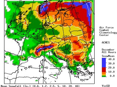 The foundational atmospheric ingredient for the creation of heavy snowfall in southern Europe and along the Alps is the convergence of two different airmasses. The most common occurrence of heavy snow is with the convergence of a cold continental and a warmer maritime airmass. This usually happens when a High advects a cold airmass from the eastern European continent into central Europe. A Low south of the Alps advects warmer moist air from the Mediterranean Sea and the Adriatic Sea causing overrunning precipitation. This also occurs with a closed upper level Low moving east across the Mediterranean Sea producing the same overrunning effect. An important reminder is to match the synoptic situation with surface and boundary layer temperatures. The UKMO model, produced by the United Kindgom Meteorological Office is useful for European weather forecasting; however, it was developed for the UK and not southern Germany. It doesn’t take into account the terrain differences and can underestimate forecast precipitation. The 1000-500 mb thickness chart is useful for forecasting snow but the tropopause is lower in Europe due to the latitude difference. Instead of the 5400 thickness for snow, use the 5280. It might be better to use the 1000-850 mb thickness taking into account the lower levels. Snow can be expected with a thickness value of 1280-1300. The 850-700 mb will give a good depiction of mid level warm air advection or overriding warmer moist air. The Air Force Weather Agency’s Technical Notes 98-002 gives the forecaster general guidelines for forecasting heavy snow. Heavy snow can be expected if all of the following conditions are met on the upper air analysis. If the 850-mb dew point is in the range of –5° to 0°C, the 700-mb dew point is warmer than –10° to –5°C, the 500-mb temperature is less than or equal to –35°C than heavy snow can be expected. Also, a method of analysis for pinpointing specific areas of heavy snowfall is given. First, outline the surface 0°C (32°F) isotherm and 0°C (32°F) dew points. Next, outline areas having dew points < 4°C and moisture at 850 mb. Then at 700 mb, outline areas having dew points < 10°C and moisture. Next, at 500mb locate the jet if there is one (–20°C isotherm is a good indicator) and cold thermal troughs. Also, outline areas of 80 percent RH between the surface to 500 mb. Examine positive vorticity advection (PVA) and 12-hour forecast position of the PVA. Analyze thickness in the low level from 850-700 mb for areas 1,520 to 1,540 meter. This should be a good pointer to the heavy snowfall zone. It shouldn’t be more than 200 miles and heaviest fall is 2 to 4 degrees of latitude on the cold side of the surface low. Where all of these areas converge will be your pinpoint heavy snowfall forecast area. The consequences of heavy snowfall to the hilly areas in southern Germany and to the high mountain peaks of the Alps are both negative and positive. Negative impacts are clearly the delays in transportation from the Autobahns to the Airports. Schools and businesses will close and this will delay progress in educational and economic goals. From a safety standpoint, automobile accidents will happen and people may get stuck inside their vehicles. The positive impacts are mainly recreational and rest related to the skiers desiring the majestic peaks to have a fresh new coat of snow and children wanting to build snowmen and forts. From the skier or snowboarder’s dream come true to the motorist’s nightmare, heavy snow in southern Germany and the Alps is an important weather condition that most people living in the region are concerned about. The heavy snow forecast can be improved through continual analysis, diligent use of weather tools and continued study of the state of the atmosphere. As the upper air charts become available continue to scan them carefully for any change to the atmospheric condition. Don’t just stop at the charts. Be sure to interrogate the skew-t data from upstream stations. Every hour examine the surface data to recognize the changes occurring, especially as the onset of snow approaches your station. See how the models are handling the situation. Constant examination of the meteorological state using satellite and radar are crucial. German and southern European weather forecasting would benefit greatly with a Doppler radar network and a mesonet across the very data sparse regions such as the Alps. Last but not least, keep an eye out for any pilot reports or air reports. Sometimes the aviator can be the weather forecaster’s best friend in being a forward looking eye to the real atmospheric conditions. References: Air Force Combat Climotology Center. https://notus2.afccc.af.mil/SCISPublic Illesheim Army Airfield Forecast Reference Material, 21 OWS Technical Services. Bundenthal, Thomas. Winter Weather Controls and Forecasting Snow in Central EuropeCentral Europe. 21 OWS Technical Services. 2000. Mireles, Mark, Kirth Pederson, and Charles Elford. AFWA TN-98/002 Meteorological Techniques. 13th. Offutt Air Force Base, NE: USAF, 2007. |