
The New York metropolitan area is one dominated by the presence of water. This coastal region ("anchored" by a literal urban heat island) is roughly 300 square miles. It's located on the Atlantic coastal basin at the mouth of the Hudson River. All but one of New York's five boroughs are islands. The Long Island and New Jersey coasts are at right angles to one another. All the major waterways (Atlantic, Long Island Sound, Jamaica Bay, etc.) have different water temperatures. About 30 miles to the north and west, elevations rise to about 1500 feet. This topography itself presents many forecasting challenges, not the least of which concerns the type and amount of winter precipitation. However, in this discussion we are limiting ourselves to the sea breeze phenomenon in the Spring and Summer months. It is true that sea breeze circulations are present and have very real implications throughout the year in the New York metro area. In winter months, the relatively warm waters of the Atlantic help modify temperatures. But it is in the warmer months that sea breezes (and sea breeze fronts) can dramatically cool things down, and in effect, act as Mother Nature's air conditioner. The sea breeze circulation is the result of the two opposing of flows of surface (sea) and return (aloft). The flows themselves are the result of differences in air pressure above land and sea, created by the sun's heating. 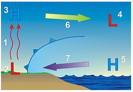 Because of the temperature difference between the temperature over land and over water are usually large, a boundary (i.e. cold front) can develop. The resulting sea breeze front acts much like a cold front, and can drop temperatures up to 20F degrees. Visitors to Long Island's south shore are most delighted by this minor meteorological miracle. While their unfortunate friends and relatives broil in the sticky sweltering mess of a Manhattan August, they enjoy cool comfortable breezes (and lower humidity) just miles away. But many times, the full cooling effect is not felt until a few hundred feet of the water. In early summer, the South Shore can routinely experience daytime highs up to 30F degrees cooler than Central Park, or even interior Long Island. This is generally when the SST is still very cold. The cycle typically begins by mid-morning. If there are no interfering winds or weather conditions, the sea breeze will blow across the Island by middle to late afternoon, bringing a light southerly wind to the North Shore. When the breeze is strong enough, it will continue to Connecticut. When it is weaker, it may barely reach the Long Island Expressway. When even moderate westerly winds are present, the sea breeze is wiped out by the strong warm dry air. A pleasant drop in temperature is not the only product of sea breeze circulation. Sometimes these winds can have a hand in severe and even deadly weather. On August 4, 2002 a man was struck and killed by lightning in Chinatown New York City. He was on his roof to watch an incoming storm. Lightning struck the ground between 5,000 and 7,000 times during this event. The heat and stifling humidity provided the fuel for the storm. A weak cold front from southwest Canada was the trigger. But there was an additional element that helped trigger the lightning as the storms moved south. A sea breeze had developed, bringing cooler air from the Long Island Sound to form another front. All of it came together with deadly results. Much has been done over the years to aid forecasters in handling the sea breeze in the New York area, as a result of the increased density of surface observations and high-resolution mesoscale models such as he fifth generation Pennsylvania State University- NCAR Mesoscale Model version 3 (MM5). According to its designers, the MM5 is a "limited-area, nonhydrostatic, terrain-following sigma-coordinate model designed to simulate or predict mesoscale atmospheric circulation." 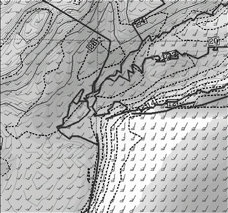 This figure shows at conditions at 1200 UTC 28 March 1998 with corrected SST and reservoir temperature and 27 sigma levels. Shading indicates low humidity over land and fog over water. The use of LIDAR (Light Detection And Ranging) has also improved the accuracy of these forecasts. After the tragedy of September 11, 2001 the City College of New York (CCNY) installed LIDAR to monitor the atmospheric environment over New York City. The purpose was to detect and track aerosol layers aloft. The Lidar profiles also identify mesoscale weather patterns like sea breezes. The ABL is the most prominent feature picked up by the Lidar system, and forecasters can look at the thickening of the ABL as an indication of a passing sea breeze front. Spring and Summer sea breezes continue to present many challenges to New York City forecasters. Pinpointing the timing and boundary of the fronts, and accurately forecasting temperatures in the region are especially tricky. A persistent east/northeast flow can wreck a forecast with the resulting overcast sky and cool moist air. A familiarity with the geography and topography of the area, in addition to better model analysis can aid in providing more accurate forecasts. REFERENCES Observations and Simulations of Intense Spring Sea Breezes Along the New York - New Jersey Coast Stanley David Gedzelman* and Kwan-yin Kong EAS Department and NOAA CREST Center, CCNY FAIR WEATHER CLIMATOLOGY REVEALED BY THE CCNY LIDAR Stanley David Gedzelman*, Kwan-yin Kong, Fred Moshary, Heather Yael Glickman, Barry Gross, and Leona Charles NOAA Crest Center, City College of New York NWS Jet Stream Online School "Lightning Victim Atop Building Is Identified ," New York Times, August 4, 2002 |