
Winter weather forecasting can be challenging for any weather forecaster. Even forecasters in areas that normally receive winter precipitation on a regular basis miss their predictions by wide margins at times. These misses are due in part to the subtle changes in the track a winter storm might take. A change of a few miles over a forecast period could mean the difference between rain and snow mix or a foot of snowfall. Geographically speaking, Atlanta is at a challenging location in the Southeast. It is located at the base of the Appalachian Mountains in the foothills region of Georgia. To its South is the Piedmont region followed by the Coastal Plains and Lowlands. Atlanta is also located several hours from two major sources of cyclone development, the Gulf of Mexico and the Atlantic Ocean. Atlanta's geographical location is one factor that makes winter weather forecasting a challenge. The other factor is its geographical size. Atlanta is ranked as the ninth largest metro area in population wise with over five million residents. Atlanta's metro area consists of twenty-eight counties. This encompasses an area of over 8,000 square miles. That is a lot of area to forecast for on a local scale. The northern metro borders the Appalachian Mountains. Some areas in those counties have ridges that are over 2,000 feet in elevation. The southern counties lie in the Piedmont region. They have elevations of around 1,000 feet. This urban sprawl of Atlanta has created an area too large to accurately forecast winter weather for the entire area involved. There are three major sources of winter weather events Atlanta and the Deep South has to possibly deal with each winter. The first and most frequent are Gulf of Mexico cyclones. Next are cold air damming and arctic frontal boundaries. Each of these three storm systems presents unique challenges to different parts of Atlanta's metro area. In each case there is very rarely complete coverage of winter precipitation over the entire region. The most familiar storm system to affect Atlanta is Gulf of Mexico cyclones. This storm system usually form somewhere in the Northwestern Gulf of Mexico. The low usually develops along the Northern coast of Texas or South of the Louisiana coast. As the low deepens it tracks North Eastward. This track takes the center across the Florida panhandle and eventually to the Georgia and Carolina coastal region. As the low deepens and progresses there usually will be an intrusion of Arctic air either behind the low or an Arctic air mass will already be in place over the South. Often times Atlanta's location puts the city right at the juncture of the two systems. Two main challenges come into play for Atlanta during this event. The first challenge is to figure out the exact track of the low. Any deviation may totally blow the forecast. A little jog North and its all rain. A jog too far south, and its nothing for Atlanta. The other big question is will the Arctic air be in place. In some situations the arctic air has not reached the area when the low starts to form. It then becomes a race to see which gets to Atlanta first, the moisture or the cold air. Once these variables have been nailed down the next challenge is to find out where the heavy snow band will set up and how much precipitation will accumulate. This is when Atlanta's sprawl makes an accurate forecast confusing for Atlanta's five million residents. The best example of this scenario is the super storm of 1993, the storm of the century. For that storm the forecast for Atlanta was three to six inches of snow. By the end of the storm the National Weather Service, Located well South of Atlanta, only reported a wimpy four inches. Areas to the North in the metros Northern counties saw amounts of twelve to eighteen inches of snow. This is a great example of how sprawl can throw a forecast into a tailspin. The other scenario that Atlanta may have to deal with is cold air damming. Periodically a cold, arctic high will settle over the North Eastern portion of Canada. At the same time low pressure develops off the South Eastern coast. This creates a strong North Easterly flow over the Atlanta metro area. Due to its location at the base of the Appalachians it is at the point where the cold Arctic air gets trapped or dammed. This is also referred to as a wedge. When this happens dew points drop dramatically from the western side of Atlanta to the North Eastern side of the metro area. The further you go west the dew points continue to rise sharply. With this cold and dry air mass in place the amount of evaporational cooling can be incredibly high. An example of the set up would be as follows: The South Western areas of Atlanta might have a temperature of 33 degrees with a dew point of 25 degrees while the North Eastern portions of Atlanta would have a temperature of 33 degrees with a dew point of 15 or less. Areas further West in Alabama might have temperatures well into the 40's. As the developing low off the coast throws moisture up and over the cold shallow air over Atlanta, evaporational cooling takes place. The areas North and East can potentially see heavy ice accumulations. The forecasting challenge is to find where the greatest cooling will take place. These events rarely produce accumulations of ice in the western and southern parts of Atlanta. When it does happen it's usually very light. Area in the central parts of Atlanta and especially areas North and East are more prone to damaging ice accumulations. The third winter scenario that affects Atlanta is arctic fronts. These reach Atlanta quite frequently during the winter but are usually dry systems. Sometimes the systems are followed by small impulses that rotate around an Arctic upper level low that is centered over the Northern Great Lakes. Sometimes called clippers these storms are small and move very fast. Due to their speed and lack of moisture they don't usually drop much precipitation. The challenge with these storms is to figure how far into the metro area they will rotate. Sometimes the axis they rotate on keeps them further North over the Tennessee Valley. Due to Atlanta's large area these are very hard to predict. When they do move into the metro area the Northern burbs are most likely to see any snowfall. Rarely does the Southern part of Atlanta see anything out of these small storms. Another aspect of Arctic fronts that affects Atlanta is the CAA that follows the front. Sometimes this occurs and is strong enough to squeeze out accumulating snow, usually less than one inch. Most of the time these events are not predicted at all or only occur in isolated parts of the metros sprawled out counties. Atlanta's sprawl has created one of the largest geographically spread cities in the country. This coupled with its geographic location certainly have made Atlanta a challenge for many forecasters. Winter weather can also be highly unpredictable. All of these factors make Atlanta a unique venue for the study of winter weather systems. 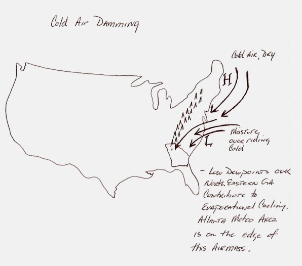 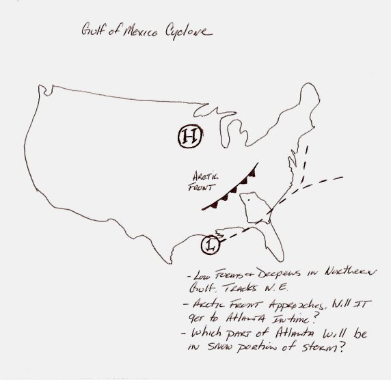 |